|
|
Post by pistonschick on Apr 22, 2015 8:16:33 GMT -8
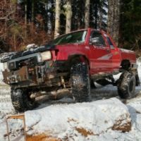
Please join us on Saturday - May 2nd, 2015 for the 13th Annual Pick Up the BurnImmediately following lunch after the clean up event we invite you to attend the Grand Opening of the Brand New 4x4 Trails.Mountain View Trail (formally known as C1)Deer Pen Trail (formally known as C2)Hagen Creek Trail (formally known as C3 & C4)Piston's Wild Motorsports and Jones Creek Trail Riders worked hard all last summer and again for the last two weeks volunteering over 8,000 hours to build the new motorized trails and they will all be open to the public on May 2nd, 2015. * Grand Opening status is subject to change at any timeREQUIREMENTS YOU WILL NEED TO BE ON THE TRAILS:1) If your vehicle has a street plate with current tags you will need a Discover Pass to access the trails.
2) If you participate in the Pick up the Burn and check in at registration - you will receive a FREE one day use Discover Pass that will provide access on May 2nd, 2015 only.
3) If you vehicle is not street legal you will need to have a current OHV permit from the state in which you reside (your driver's license home state must match)
4) If you trailer your vehicle into the forest - you will also need to have a separate Discover Pass for your tow vehicleIf you have any questions about the Pick Up the Burn - please contact Jason Lenz (DNR) @ (360) 356-0535 If you have any questions about the 4x4 Trails Grand Opening - please contact Crystal Crowder (Piston's Wild) @ (360) 606-1648 We look forward to having a large 4x4 turnout at the Pick Up the Burn and at the Grand Opening of the new trails! Please show up to represent your sport and let DNR know how important it is to you to have 4x4 trails on Washington State Lands. See you on the trails! 
|
|
|
|
Post by navyjeepster on Apr 23, 2015 10:01:22 GMT -8
We shared this on the BRC Facebook page.
Todd Ockert
BRC President
|
|
|
|
Post by ljdude on Apr 23, 2015 13:17:21 GMT -8
Thank you for doing that.
|
|
|
|
Post by petee on Apr 29, 2015 9:27:34 GMT -8
Is anyone else as excited as me about Saturday?
I just have to say again well done crew for all the hard work and dedication this has taken so far. A another special shout out to Darel and Crystal Crowder for their endless love for this sport and perseverance to see this through. I'm proud to be associated with those two.
Thanks everyone and see you Saturday.
|
|
|
|
Post by bigstuck on Apr 29, 2015 12:27:12 GMT -8
I second what Paul said. Thanks Darel and Crystal your guys dedication to this project and seeing it through we cannot thank you guys enough. To the club thanks to all you folks that spent all the hours working and building along with Darel and Crystal to help bring it to what it is for this weekends opener.
I am super stoked to come down and see all your guys hard work! Ill be there bright and early Saturday morning to help get things rolling then enjoy the new trails in the afternoon!
|
|
zukpaz
Winch Cable Monkey

Posts: 5 
|
Post by zukpaz on Apr 29, 2015 14:12:43 GMT -8
Is there enough room for trucks hauling their 4x4's on trailers?.....Last time I went to the Jones Creek Staging area, it was kinda small for a lot of truck-trailers (Thanks for all the hard work up there!!!)
|
|
|
|
Post by petee on Apr 30, 2015 5:53:08 GMT -8
Zukpak yes it is small. I would say get there early or you can find a spot up the road. Don't let it stop you from coming....
|
|
zukpaz
Winch Cable Monkey
Posts: 5
|
Post by zukpaz on Apr 30, 2015 14:05:38 GMT -8
Cool.....Thank you!....Hope to see you there  |
|
|
|
Post by ljdude on Apr 30, 2015 20:02:16 GMT -8
For those that need some directions to Jones Creek Trail Head.
Take I-205 exit toward Vancouver, WA. Use Highway 500 East (Exit 30-Orchards Exit). Go east on Highway 500 to Fourth Plain (1st light) and turn right continuing on Highway 500 East (Camas). Go 6.3 miles, then turn left on 53rd Street. Go 3.2 miles, and turn left on Ireland Road. Go 0.3 miles and turn left on Lessard Road. Continue on Lessard Road (turns into Boulder Rd.) for 4 miles. Veer left at the fork, and proceed toward the parking lot/staging area.
|
|
ExCabSwap
Active Member  Active Member
Posts: 264
|
Post by ExCabSwap on May 1, 2015 7:52:44 GMT -8
Traveling from 164th and 4th Plain, would you say the above route is faster than going up through 4 corners, and past the trails, coming down onto JC Trail Head?
I've never gotten there the way you said, but if it's faster, I'll try it.
|
|
|
|
Post by pistonschick on May 1, 2015 8:56:56 GMT -8
Traveling from 164th and 4th Plain, would you say the above route is faster than going up through 4 corners, and past the trails, coming down onto JC Trail Head? I've never gotten there the way you said, but if it's faster, I'll try it. Phil - you already know how to get there. This post was not for you... Daryl was just posting the most direct route to the Jones Creek Trailhead for the members of the public who may not know how to get there... |
|
Wyldman
Active Member
Safety & Education Chairman
IXOYE
Posts: 643
|
Post by Wyldman on May 3, 2015 18:59:47 GMT -8
How was that for a day!!!! I had an awesome time. The event couldn't have gone any easier. We cleaned the forest and then we OPENED TRAILS!!!!! Oh.... Then we sat around ate good dogs and potato salad and told stories. Fantastic!
Thanks to everyone who came out and supported the cause.
Douglas
|
|
|
|
Post by Scoundrel on May 5, 2015 7:57:10 GMT -8
Greetings!
I'm getting ready to make the long trip from just north of Seattle to check out the Yacolt Burn 4x4 trails.
Thank you for your time and effort cleaning up the trails!
I would very much appreciate any pointers you can give me to make this long trip go smoothly.
Is there a map showing where the trails are, where they go, and what their names are?
Is there good signage on site so once I get to the parking area, I'll be able to find them?
How are the new, legal trails distinguished from the often-used, but illegal trails?
Thanks again!
|
|
|
|
Post by ljdude on May 5, 2015 13:22:55 GMT -8
Greetings! I'm getting ready to make the long trip from just north of Seattle to check out the Yacolt Burn 4x4 trails. Thank you for your time and effort cleaning up the trails! I would very much appreciate any pointers you can give me to make this long trip go smoothly. Is there a map showing where the trails are, where they go, and what their names are? Is there good signage on site so once I get to the parking area, I'll be able to find them? How are the new, legal trails distinguished from the often-used, but illegal trails? Thanks again! Hey scoundrel. Here is a link to all of the DNR recreation maps for Washington State. www.dnr.wa.gov/RecreationEducation/Topics/TrailsMapsFacilities/Pages/trail_maps.aspxJust click on the Yacolt Burn Motorized Trails map for a map of "The Burn". The trails are well marked so there shouldnt be any issues of you trying to distinguish between the legal and illegal trails up there. When are you planning on coming down? Maybe a member or two from the club could give you a tour of the trails if our schedules aline. Daryl |
|
|
|
Post by Scoundrel on May 5, 2015 14:20:09 GMT -8
Thank you for the reply, Daryl! I was thinking of making the trip on Saturday, June 6th.
I had seen a similar map in my searches that only included ATV/Motorcycle trails, and a map on jctra.org that indicated proposed 4x4 trails, but had not yet seen this map despite searching for it. Thank you for the direct link.
Are you willing to field a few more questions?
I am now trying to interpret this map. It looks to me as if the best way to access the 4x4 trails would be to enter by way of the Jones Creek ORV Trailhead, and go up the road marked as L-1600 on the DNR map (Google disagrees on the naming), turn left at L-1500, and proceed to where the 4x4 trails begin. Is that correct?
Are ORVs allowed on L-1600 and L-1500, and the surrounding roads (L-1520, L-1552, L-1580, etc) with or without WATV plates and street legal kits?
Given that this is DNR land (not USFS), and there is a note about not riding in the powerline corridor, which is a good distance from the nearest ORV trails, that probably means it's OK to drive ORVs on those roads, but the map does not specify and I don't want to assume anything. It looks like there is approximately 3 miles of actual 4x4 trails, so I'm hoping the service roads are open too, or it will be a short ride for such a long trip.
There is one more question I'd like to cover, perhaps the most important. And it would be easy for people to take it wrong, so I am going to be very careful with my wording and explain my perspective first:
Not long ago, after years of closure, the DNR built some 4x4 trails at "Reiter Foothills". There are only a couple miles of them, but I figured it was worth checking out, since I live fairly close to there.
What I found there was not exactly trails that are accessible by 4x4 vehicles. Instead, They are trails that were designed specifically for 4x4 vehicles. The distinction is that these trails were not at all friendly to UTVs, ATVs, or dirt bikes. They were brutal, and I am amazed I got out of there without breaking anything. It was not enjoyable for me.
So the question is: Are these 4x4 trails considered "multiple use", or are they engineered specifically for vehicles with high ground clearance and 35" or larger tires?
Are they "crawling" trails, where 3 miles will take most of the day and body damage is expected?
If that is the case, I have no problem with that and I hope that you have loads of fun on them - but that would dissuade me from visiting.
I am looking forward to your reply, and once again thank you for your time.
|
|